

OPTIMASI TATA GUNA LAHAN DAN PENERAPAN REKAYASA TEKNIK DALAM ANALISA BANJIR DI DAERAH ALIRAN SUNGAI: STUDI KASUS DAERAH ALIRAN SUNGAI CILIWUNG HULU DI BENDUNG KATULAMPA (The Optimization of Land Use and the Application of Engineering Treatment in Flood)
Yohana Lilis Handayani(1*), Rachmad Jayadi(2), Bambang Trihatmodjo(3)
(1) Program Studi Teknik Sipil, Program Pascasarjana Universitas Gadjah Mada, Yogyakarta
(2) Jurusan Teknik Sipil, Fakultas Teknik, Universitas Gadjah Mada, Yogyakarta
(3) Jurusan Teknik Sipil, Fakultas Teknik, Universitas Gadjah Mada, Yogyakarta
(*) Corresponding Author
Abstract
ABSTRAK
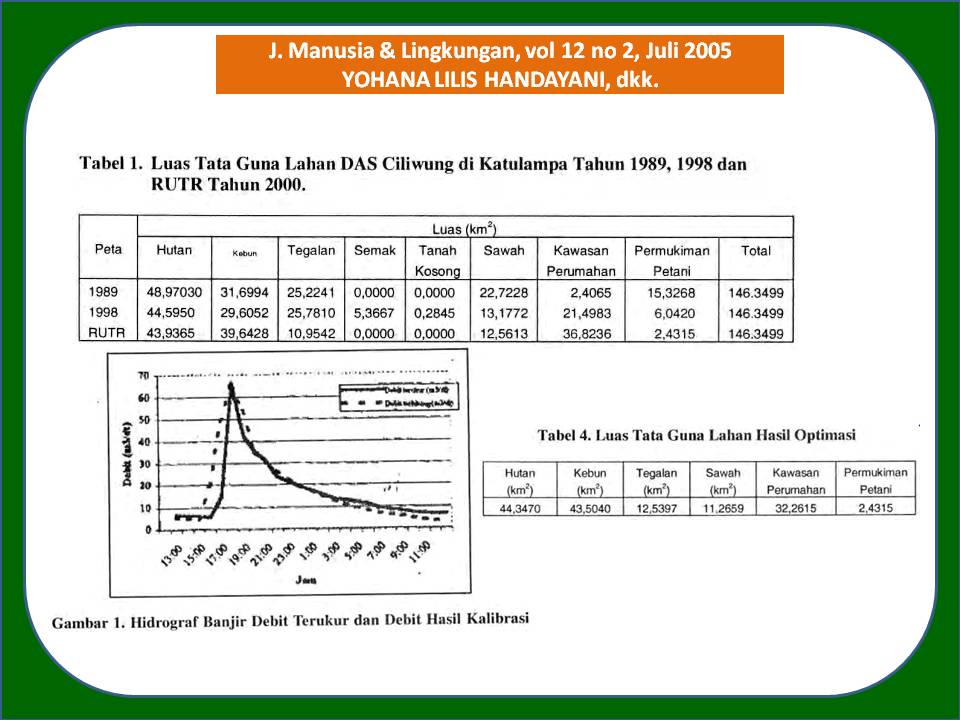
Peningkatan aliran puncak dan volume runoff dari flood hydrograph dapat disebabkan oleh konversi penggunaan lahan. Fenomena ini terjadi di cekungan hulu sungai Ciliwung sebagai daerah konservasi. DAS ini memiliki peran penting dalam memelihara ketersediaan air di cekungan Ciliwung dan untuk pengendalian banjir di daerah hilir. Berdasarkan data yang dicatat dari 1993 sampai dengan 1996, 14,6% kejadian banjir di daerah hilir disebabkan oleh banjir kiriman. Evaluasi konversi penggunaan lahan di daerah hulu Ciliwung dilakukan dengan membandingkan penggunaan lahan tahun 1989 dan 1998. Optimasi tata guna lahan dilakukan dengan optimasi linier untuk meminimasi nilai koefisien composite runoff. Pendekatan teknis dan penerapan rekayasa teknik digunakan untuk simulasi penurunan aliran puncak dan volume runoff dari flood hydrograph. Perlakuan ini meliputi terracing dan normalisasi kolam detensi (detention pond). Simulasi dilakukan untuk periode banjir 10 tahunan. Hasil analisis menunjukkan bahwa dalam periode 10 tahun (1989-1998) penggunaan lahan dikonversi secara signifikan. Konversi ini menyebabkan peningkatan aliran puncak dan volume runoff masing-masing 18,97% dan 18,87%.
ABSTRACT
The risk of peak flow and runoff volume of a flood hydrograph may be caused by land use conversion. This phenomenon had happened in upstream of Ciliwung basin. As a conversation area, this catchment has an important role in maintaining the water availability of Ciliwung basin and for flood control in downstream area. Based on the collected flood data recorded from 1993 to 1996, 14.6% of flood events in downstream of Ciliwung basin were caused by delivery flood from upstream area. Evaluation of land use conversion in upstream of Ciliwung basin was carried out by comparing land use in 1989 and in 1998. Land use optimization was done using linear optimization to minimize the value of composite runoff coefficient. Technical approach of engineering treatment was used to provide simulation to decrease peak flow and runoff volume of a flood hydrograph. The treatment consist of terracing and normalizing of detention pond. Peak flow and runoff volume of a flood hydrograph were simulated 10 years return period of storm. The results of analysis indicated that during 10 years (1989-1998) the land use converted significantly. The conversation of land use cause to increase the peak flow and the runoff volume of 18.97% and 18.87%, respectively.
Full Text:
Artikel lengkap (PDF) (Bahasa Indonesia)Article Metrics
Refbacks
- There are currently no refbacks.
Copyright (c) 2017 Jurnal Manusia dan Lingkungan
JML Indexed by: